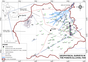
From 2014 to 2017 several geophysical campaign were performed in the Punata alluvial fan. More than 30 km of Electrical Resitivity Tomography (ERT) were collected. In some ERT surveys the Normalized Chargeability was also retrieved. So far 130 sounding of Time Domain Electromagnetic (TDEM) were collected. Archive information from previous studies are also available: 15 resistivity borehole loggings and 65 lithology reports.
ERT results
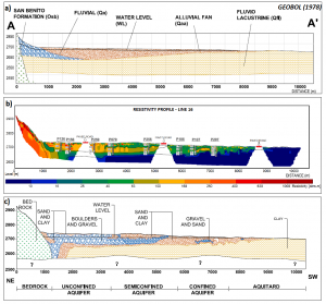
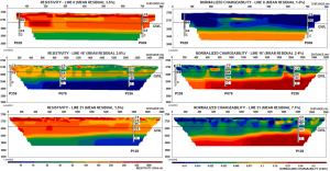
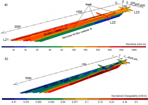
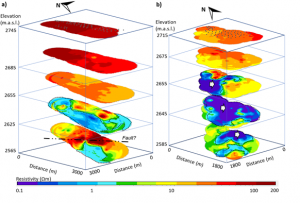
The Punata alluvial fan characterization indicated that the top part of the subsurface is composed of boulders in a matrix of finer particles and that the grain size decreases with depth; the electrical resistivity of these deposits ranged from 200 to 1000 Ωm, while the values of normalized chargeability were lower than 0.05 mS/m. The bottom of the aquifer system consisted of a layer with high clay content, and the resistivity ranged from 10 to 100 Ωm, while the normalized chargeability is higher than 0.07 mS/m.
For more information about ERT results, click here.
TEM
The analysis and interpretation of the TEM showed a very low resistivity zone in the aquifer system bottom. This zone is related to saline water, which might have an origin in the Pliocene, where paleolakes deposited saline material. The results pointed out that this method is much more sensitive to layers with low resistivity. Same patterns in the subsurface resistivity distribution were obtained with both ERT and TDEM.

Geophysical surveys are improving and refining the hydrogeological conceptual models in the Punata region. These models can be useful tools for proposing protection and sustainable management plans.