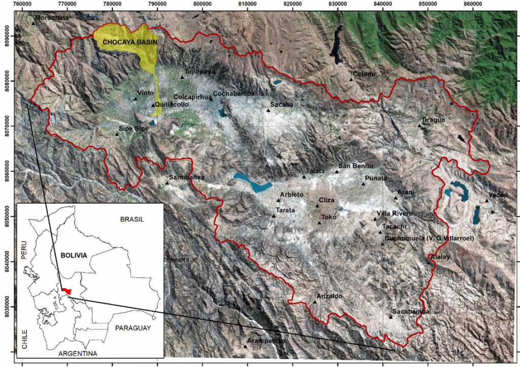
The Rocha River Basin is located in the central part of Bolivia. It is crossed by the Rocha River which has an extension of 115 km and it is a tributary of the Amazon River. The Rocha river basin forms a valley surrounded by the Andes range (refer to Figure 1). It holds the fourth largest city of Bolivia, which is Cochabamba. However, due to a rapidly and high increase of population, in Cochabamba itself and in the nearby municipalities (i.e. Sacaba, Cochabamba, Colcapirhua, Quillacollo, Vinto and Sipe Sipe), the term of metropolitan area of Cochabamba is now being used. The metropolitan region of Cochabamba has a population around of 1 million inhabitants. The bad urban planning plus a lack of environmental regulations is threatening the natural resources in the metropolitan region of Cochabamba (e.g. air and water pollution, deforestation, and loss of agricultural lands).

For instance, the industrial activities, which is poorly regulated and a bad wastewater treatment is directly polluting the water bodies. The River Rocha has been labelled as highly unsuitable for drinking and irrigation purposes due to heavy loads of organic and metals concentrations. The deterioration in the environment and decrease of water quality (and quantity) in many parts of the Rocha River Basin has driven to Universidad Mayor de San Simon (UMSS) to create a network conformed by different research has decided to use as a study case the Chocacaya basin, located in the north‐west part of the Rocha River basin (shaded yellowish area in Figure 1).
The Chocaya basin has been chosen for different reason. For instance, in the highlands is located one of the largest dams, Misicuni dam, in Bolivia (the construction finished in 2018), and will supply water to many regions within the Rocha river basin. However, before the construction of this dam many wells were drilled in the Chocaya alluvial fan (outlet of the Chocaya basin). These wells supply drinking water to the Cochabamba city and are labelled as deep wells due to the fact that they can be as deep as 300 m below ground‐surface. Furthermore, within the Chocaya basin a rapidly urbanization is being undertaken in different zones including the river banks (flood plains). These flood plains are important, from a hydrogeological point of view, since these areas are considered as a groundwater recharge zones. Therefore, there might be consequences from these anthropogenic activities such as decrease in groundwater recharge and also pollution of surface water and groundwater.
For the previously mentioned reasons the water‐soil network at UMSS is designing three projects based in the
Chocaya basin:
- Project 1: In the upper part of the Chocaya basin the focus will be the degradation of ecosystems and natural resources (e.g. surface water, soils and vegetation) and natural hazards (i.e. floods and landslides)
- Project 2: In the middle part of the Chocaya basin (alluvial fans) groundwater will be studied in detail (i.e. geometry characterization, recharge/discharge process, water quality, and groundwater
- (over?)exploitation). Project 3: In the lower part of the Chocaya basin, the effects of the re‐use of wastewater over the human health, Rocha River, soils and groundwater will be studied.
In order to contribute in the generation of important and useful information for project 2, the research units
Laboratório de Hidráulica (hydraulics lab) and Centro Agua at UMSS, together with Engineering Geology at Lund University, and with funding from SIDA (Swedish International Development Cooperation Agency) and Geoscientists Without Borders, are planning to perform geophysical investigation campaigns in the surroundings of Chocaya basin.
The geophysical results and its interpretation might contribute in having a better understanding about the layering, thicknesses and lateral extension of the aquifer system at Chocaya basin. Moreover, the use of geophysics can assist in determining which are the potential areas for groundwater recharge, and map the delimitation of groundwater with different quality (e.g. fresh and salt groundwater).
